Awakening the Bear |
|
Assessing Flow Improvement Needs and Opportunities
|
|||||||||||||||||||||||||
|
|||||||||
|
Over the past three years, Environmental Defense and its partners(2) undertook a variety of efforts to address the needs and potential opportunities for improving flows in northern California’s Bear River, among the most heavily-manipulated and environmentally-neglected rivers in our state. The following pages summarize our work and key findings through the end of 2004, including efforts to ensure that the needs of the Bear River will continue to be addressed as part of a comprehensive regional portfolio of conservation initiatives for the Bear, Yuba, and American River water management systems. This report also includes selected links to the library of project-related documents on the accompanying CD, including notes, data, analysis, digital maps, contacts, and references. (The project bibliography references many documents which are not included on the CD, however most are available online and/or are on file with the authors.)
Sandwiched in between the Yuba and American River basins in the west-central Sierra Nevada, the Bear River – an early victim of geologic and glacial stream capture – supported thriving populations of salmon, trout, and other native species throughout its pre-development history. The Bear River’s riparian zone served as an important wildlife migration corridor from its confluence with the Feather River to its headwaters near Bear Valley, and its watershed was a central part of the Nisenan people’s ancestral homeland.
The Bear’s real problems began during the gold rush era, when the combined effects of hydraulic mining and massive imports of mercury severely degraded the once-pristine River. By the late 1800’s, hydraulic mining had largely given way to inter-basin water and hydropower development which served agricultural water supply and power generation needs throughout the western foothills region (and beyond). By the turn of the 20th century, much of the region’s contemporary water infrastructure was in place.
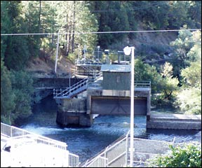 |
The Bear River Canal headworks |
In the 1960’s, when foothills-area growth got underway in earnest, some of the original water and hydropower infrastructure was replaced or expanded while several new dams, powerhouses, and conveyance works were added. Throughout this period, the Bear River became, quite literally, the region’s hydraulic workhorse, conveying water for consumption and energy generation from the upper Yuba, upper American, and its own headwaters and tributaries into the middle and lower Bear, the lower American, and the associated foothill creek-ravine region.
Today the Bear River can be divided into three basic reaches: (1) an “upper” or headwaters reach from just above Bear Valley to Rollins Reservoir; (2) a “middle” reach from the Bear River Canal headworks immediately below Rollins Dam through Combie Dam and Reservoir to New Camp Far West (NCFW) Reservoir; and (3) a “lower” reach from the South Sutter Water District (SSWD) diversion dam below NCFW Dam to the Bear-Feather River confluence. (The enclosed Bear River plumbing schematic combines (2) and (3) above into a single “lower” section.)
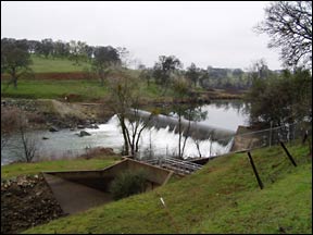 |
South Sutter Water District (SSWD) diversion
dam |
For much of the past two decades, considerable attention has been drawn to the plights of the Yuba and American Rivers, and much has been accomplished to address at least some of their basic needs. Among the most recent of these efforts has been the Upper Yuba River Studies Program (UYRSP), a $9 million agency-stakeholder collaborative funded by the CALFED Bay-Delta Program to determine the feasibility of restoring salmon and steelhead into the upper Yuba River system (www.upperyuba.com/yuba).(3)
One of the early outcomes of the UYRSP was an agreement to leave water purveyors “whole” in the event that restoration efforts led to adverse water supply impacts. An important consequence of that commitment was the realization that the contemporary water management system inextricably commingled waters from, and to, a number of different watersheds. The relevant “problemshed” thus includes the entire Bear River watershed; the associated “source” watersheds of the Middle Yuba, South Yuba, and North Fork American Rivers; the many foothill watersheds that depend in part upon those same inter-basin supplies; and the associated service areas of the Nevada Irrigation District, Placer County Water Agency, South Sutter Water District, and Pacific Gas and Electric Company, among others.
After considerable early progress, the UYRSP ground to a temporary halt in 2001-02 due to a combination of state budgetary woes and related problems at CALFED. At that time, Environmental Defense decided to focus on the non-Yuba portions of the problem-shed, seeking to better understand the potential for UYRSP-related impacts on consumptive water supplies, hydropower operations, and the environment.
The non-Yuba portions of the problem-shed include a number of sites that are worthy candidates for conservation action in their own right. Among these are the “salmon occupied” reaches of the lower Bear River as well as Auburn Ravine-Coon Creek, Dry Creek-Secret Ravine-Miners Ravine, and Dry Creek-Spenceville; the middle reach of the Bear River, where gold-rush era mercury deposits continue to cause problems; and the upper reaches of the Bear, including a viable native trout fishery (in Bear Valley) that was already the focus of important restoration efforts.
While modest flow improvements would no-doubt be beneficial in the upper reaches of the Bear, our efforts came to focus on its middle and lower reaches, and on the various foothill streams, where diversions are greatest, where flow improvements will depend on the effective re-management of co-mingled inter-basin supplies, and where the regional potential to protect and restore anadramous fish across a diverse array of sites remains high. (In each instance, of course, both flow and non-flow improvements will be needed.) Work to improve flows across a diverse array of sites also underscores the need for a region-wide alliance of restoration advocates, as discussed further below.
The middle reach of the Bear River is perhaps the least understood of the sites noted above when it comes to identifying flow-related improvement needs and opportunities. Key challenges for the middle Bear include the following:
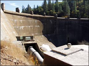 |
Combie Dam |
In the lower reach of the Bear, flow improvements may be easier to justify due to the below-dam potential for anadramous fishery restoration; these, in turn, could also serve as a “magnet” for accompanying middle-reach improvements. Even so, a number of problems remain:
In addition to all the above, any effort to improve flows in the Bear River system will depend on the development of agreements and understandings with Nevada Irrigation District, Pacific Gas and Electric Company, South Sutter Water District, Placer County Water Agency, and possibly other entities who control and manage water in the system. Flow improvement initiatives can also be advanced through the Federal Energy Regulatory Commission (FERC) license renewal processes for the Drum-Spaulding, Yuba-Bear, and Middle Fork hydropower projects, and/or through other regulatory proceedings, however cooperative strategies have been the focus of this project.
Finally, the contemporary reliance on Yuba (and to a lesser extent American) River imports into the Bear River system leads to concerns among advocates for those resources when considering Bear River and related flow improvements that might constrain future opportunities to “recapture” even a portion of those supplies.
With the above challenges in mind, Environmental Defense and its partners sought to develop and refine the following multi-pronged approach in order to build the case for improved flows across a number of program elements:
While it was not possible to undertake or complete this entire “action agenda” over three short years, we are able to demonstrate significant progress in at least the following areas:
Foothills Water Network: The Foothills Water Network was established in 2004 as a regional network of water, environmental, and conservation activists. The FWN serves as a forum for sharing information, airing and resolving differences, and with luck, developing a mutually-supported portfolio of aquatic ecosystem restoration objectives for the Yuba-Bear-American Rivers system as a whole. The CD library of information developed as part of this project will be vested with the Network to provide a foundation for ongoing work. A modest initial grant resulted in the hiring of a part-time coordinator, who is already engaged in bridge-building and outreach efforts throughout the region.
Bear River Workgroup: In 2004 the Bear River Workgroup secured a three-year, $306,000 grant to hire a Bear River Workgroup coordinator. The coordinator’s job description envisions pursuit of a 4-point program that includes specific efforts to “enhance and restore habitat, flows, and temperatures to increase anadramous and trout fisheries to sustainable levels in the Bear River and other regional streams.” (The Bear River Workgroup differs from the FWN in that it includes both stakeholder and agency representatives whose goals will sometimes vary from those of FWN participants.)
Lower Bear River Restoration Study: The U.S. Fish and Wildlife Service has developed a competitive Request for Proposals (RFP) for studies to evaluate baseline conditions as well as fishery restoration needs and opportunities on the lower Bear River below New Camp Far West Reservoir. Issuance of the RFP now depends on the provision of federal funds through the USFWS’s Anadromous Fish Restoration Program in 2005-06.
Lower Bear River Levee Setback: The past three years have seen substantial progress towards approval and funding of a $40+ million levee setback project in the Bear/Feather confluence region. As part of its Proposition 13 Yuba/Feather Flood Control Project, the Yuba County Water Agency (YCWA) is now considering, with the support of CDFG, USFWS, and NOAA, a Final Environmental Impact Report (see Feather-Bear Rivers Levee Setback Project, November 2004) for a preferred alternative that would result in the restoration of more than 300 acres of riparian wetlands along the lower Bear River. The design of the setback project will also meet CDF&G and USFWS criteria for an enhanced fishery and wildlife area. (The Reclamation Board has approved the project, conditioned on restrictions on the total number of new houses to be constructed nearby and the provision of matching funds from residential developers.)
Agency Outreach: We engaged representatives of the South Sutter Water District over the potential for water exchanges and flow improvements in the lower Bear River and in Auburn Ravine/Coon Creek as well. We also continued with efforts to build and sustain strong working relationships with key representatives of NID, PCWA, and PG&E, and with the various state and federal agencies who have an interest in Yuba, Bear, and American River conservation efforts. (Among the concepts explored was a near-term series of “pilot” experiments in the middle and lower reaches of the Bear River that would help to improve our collective understanding of the benefits and costs of alternative flow improvement scenarios.)
Sierra Nevada Conservancy: We played only a minor role in the successful campaign by others to establish a state-chartered Sierra Nevada Conservancy in 2004. We did, however, help to ensure that its mission and authority included actions that would both protect and improve water quality.
Upper Yuba River Studies Program: We have continued to press for timely completion as well as open and transparent calibration and verification of the UYRSP-sponsored water and hydropower simulation model of the Yuba-Bear-American Rivers system. We also initiated efforts to ensure that, on completion, the model will be housed at an appropriate public agency for ongoing public use and access.
Problemshed Maps and CD Compilation: We helped to complete an initial inventory of applicable GIS resources as well as a series of GIS-based maps that document regional water infrastructure, inter-basin water mixing, and the like. These maps are available at www.locuscor.net, or in the “images” folder in the accompanying CD compilation.
The work and accomplishments described above have laid a foundation for “awakening the Bear” by advancing a comprehensive vision for improving flows and restoring habitats throughout the Yuba-Bear-American River problem-shed. We have also made progress on a number of initiatives that will be critical to realizing that vision. Yet much work remains, including the following:
In addition to all the above, it is imperative that local and regional environmental, conservation, and watershed groups develop a shared vision of and commitment to addressing river and watershed needs throughout the problem-shed. With luck, the Foothills Water Network will evolve as a critical means to this end, and the resources at issue will prosper because their needs will have been addressed through a comprehensive, diversified, and flexible set of mutually-supported options and approaches. An awakened Bear River remains a crucial part of this contemporary restoration vision.
| Home | Site Map | Contact Us | |
